понедельник, 27 апреля 2015 г.
EXPO-2017
Hosting the EXPO-2017 international exhibition in Astana is one of Kazakhstan’s key projects. The initiative of organising such a large scale event in the capital of our country belongs to the Head of State.

At EXPO-2008 in Zaragoza, Kazakhstan won a bronze medal in “C” category for interior and exterior decoration, out of 104 participating countries.
During EXPO, the city of Astana will be filled with the sounds of different cultures from all over the world.

The key theme of the international exhibition in Astana will be "Energy of the Future".

It echoes one of the most significant and globally important issues of today, a concern for the whole world: the sustainable use of energy resources.
At EXPO-2008 in Zaragoza, Kazakhstan won a bronze medal in “C” category for interior and exterior decoration, out of 104 participating countries.
During EXPO, the city of Astana will be filled with the sounds of different cultures from all over the world.
The key theme of the international exhibition in Astana will be "Energy of the Future".

The given theme will allow presenting best power saving technologies, new elaborations and technologies of using of existing alternative power sources, such as energy of the sun, wind, sea, oceanic and thermal waters.

The exhibition will also provide a powerful momentum for a systemic diversification of its economy and technological modernization of the country’s industrial and scientific base.
EXPO-2017: Opening Ceremony: www.youtube.com/watch?v=63D3t6pk8E8
The Ustyurt Plateau
Ustyurt is a plateau in Kazakhstan and Uzbekistan.The Ustyurt Plateau is a clay and stony desert.


Very often Ustyurt is called the boundary separating Europe from Asia.
The Ustyurt Plateau occupies a huge area between the Aral and Caspian Seas, and has a characteristic feature: the escarpment, a steep inaccessible slope with the height of about 150 m
The Ustyurt Plateau is especially beautiful during sunrises and sunsets.
The chalk rocks are an impressive picture at sunrise and sunset, when the white rocks are painted in purple colors.
At first sight you may overlok flora and fauna of the Ustyurt.
Gradually, getting used to the unusual weather conditions, you can see colonies of gerbils, ground squirrels and jerboas.
This area is inhabited by many birds of prey, vultures and eagles, who proudly sit on the rocks of escarpments.
You can also meet the saiga, although it is doubtful whether you succeed to make a photo of these shy and very fast animals.
Kapchagay Reservoir,

Kapchagay Reservoir, also spelled Qapshaghay Bogeni Reservoir and sometimes referred to as Lake Kapchagay, is a major reservoir in Almaty Province in southeastern Kazakhstan, approximately 60 kilometres north of Almaty. The 140 kilometre long lake is formed by a dam on the Ili River which flows from the mountains in the east towards Lake Balkhash to the northwest. It is named after the town of Kapchagay, which is located on its western bank. During the summer months the lake attracts a number of tourists from Almaty, who frequent its beachy shores on the weekends.


Kapchagai city is in the Almaty region of Kazakhstan. It is located right coast of the Kapchagai reservoir on the Ili River, 76 kilometers from the city of Almaty.
The city was established here in connection with the construction of Kapchagai hydropower stations in 19 70-1980s. At that time, large-scale construction projects gathered thousands of young people - engineers, builders - from all over the Soviet Union. As a result, not only highways, hydroelectric and thermal power plants, factories were built but also they established cities, built roads, developed infrastructure. Thus, the Soviet workers who once came to build Kapchagai hydroelectric station, settled in a new place to live and remained in Kapchagai with their families.

Today, Kapchagai population is little more than 50,000 people. It is inhabited by many ethnic groups: Kazakh, Russian, Ukrainians, Tatars, Koreans, Uighurs, Germans. In 2010 Kapchagai celebrated 40 year anniversary of its establishment.

Today, Kapchagai population is little more than 50,000 people. It is inhabited by many ethnic groups: Kazakh, Russian, Ukrainians, Tatars, Koreans, Uighurs, Germans. In 2010 Kapchagai celebrated 40 year anniversary of its establishment.
Caspian Sea.

Caspian Sea washes the western part of Kazakhstan. The name of the Sea is connected with the Caspii tribes who had settled shores from time immemorial. It had had such names as Girkanskoye, Khazarskoye, Khvalynskoye.
The first mentions about Caspian Sea and its tribes were in the works of Gerodot. The document about the Russian navigators’ visit of Caspian Sea and theirs boating is dated back to IX-X centuries. At the beginning of XVIII century Peter-I had begun the constant research of the Caspian Sea (expeditions of Bekovich-Cherkasky A. and others). Then Soimonov I.F., Ivashinsev N.A., Pallas P.S., Gmelin S.G., Karelin G.S., and others researched the Caspian Sea.
The Caspian Sea is stretched from north to south to 1200km; the medium width is 320km, the length of the shore line is about 7000km (6000km of which in the territory of Russia and other countries).

The area of waterland is 371000sqkm; the sea level is lower than ocean’s level to 28,5 (1971). The max depth is 1025m (in the southern part).

воскресенье, 26 апреля 2015 г.
Lake Balkhash
Lake Balkhash is the 12th largest lake in the world, but that characteristic is hardly what makes it interesting. This lake is bizarre because half of the lake consists of freshwater and the other half is saltwater.
 |
View from Space, April 1991 |
The phenomenon of the lake location in the desert, without runoffs, in a dry continental climate and with very little rainfall still amazes the scientists.
 |
| Desert |
The flora and fauna of Lake Balkhash are surprisingly diverse. The lake harbors almost 20 species of fishes! No wonder, that the ancient Kazakhs called the lake – “Balik As” (fish-food).


The Bektau -Ata mountain range, bordering the lake territory, is one of the most beautiful places in the North Balkhash

In clear weather, the visibility of the picturesque landscape with majestic cliffs and canyons ranges for hundreds of kilometers.


Though the tourism infrastructure here is practically underdeveloped, Lake Balkhash is still a popular place for a beach-related holiday, mainly among Kazakhs and Russians holiday makers.


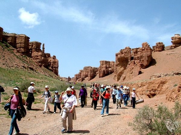
Charyn Canyon.


 The Charyn Canyon is located in the Charyn National Park about 215km east of Almaty and approximately a 3 hour drive via the A 351 and A 352. The Canyon has been described as the Grand Canyon’s little brother. This is not to detract from the sheer splendor of the canyon itself. The vista of dramatic erosion made by the river Charyn below and the elements has created a dramatic and impressive landscape.
The Canyon itself is approximately 150 km long, and, in places up to 300 meters deep.
One area of particular interest, is an area of 2km called the Valley of Castles, due to the pillars and rock formations forming imposing, almost man made structures.

The story of the Canyon is that it was formed about 3 million years ago as the land around the canyon started to rise. A very large lake existed in the area around the top of the canyon and it started to empty. Over the next million years the canyon was formed by the Charyn river. Approximately 2 million years ago a large earthquake disturbed the flow of the river by blocking it with a land-slip. The visitor part of the canyon then has suffered from the elements forming the rock sculptures. The Charyn River still flows at the bottom of the canyon forming the next great canyon. Because the area used to be a large inland sea, the deposits revealed on the sides of the canyon are relatively soft and are a geologists dream, revealing hundreds of millions of years of the earth’s history at this location.
 The Charyn Canyon is located in the Charyn National Park about 215km east of Almaty and approximately a 3 hour drive via the A 351 and A 352. The Canyon has been described as the Grand Canyon’s little brother. This is not to detract from the sheer splendor of the canyon itself. The vista of dramatic erosion made by the river Charyn below and the elements has created a dramatic and impressive landscape.
The Canyon itself is approximately 150 km long, and, in places up to 300 meters deep.
Charyn River Canyon
The canyon extends 154 km NE-SW along the Charyn River one of the deepest rivers of the northern Tien-Shan (200 km east of Almaty). The steep canyon slopes, columns and arches rise to heights of 150-300 m. The depth of the canyon has preserved a species of rare ash tree that has survived since the Ice Age, which currently still grows in some areas.
East of Almaty, 200 km by highway, is the breathtaking Valley of Castles of the Charyn river.
The Charyn Canyon is a long narrow gorge featuring steep sheer rocks with a rushing river flowing between them. Under the influence of wind and water the sandstone rocks have assumed fanciful shapes reminiscent of exotic figures and fairy-tale characters. That is why the canyons are also called the Valley of Castles, the Devil's Gorge and the Ghosts Gorge.

Подписаться на:
Комментарии (Atom)